College of Engineering Unit:
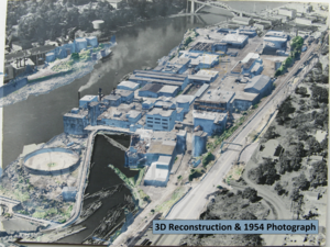
Our team is working on a test case to see if it possible in a practical manner to use LiDAR point cloud scans of locations to preserve them for historical purposes. The goal for is project is to preserve the history of a chosen site through a computer generated digital reconstruction to allow walkthroughs and flythroughs in a virtual environment, and to see if our process can be applied to future sites to allow for preservation for future generations.
This preservation would "safeguard" buildings in the case of natural disasters or demolition, as the history and context of these structures would be recorded in an alternate format. The sets of scan data were provided by Dr. Mike Olsen from the College of Civil Engineering, and this scan data was used in Unreal Engine, Metashape, and Blender to allow our team to turn .LAZ data into .FBX data through isolation and conversion through these programs, and in turn creating a full environment in Unreal Engine that users can interact with.
Our project will demonstrate the changes over time that occur with a comparison between the current site data and historical photographs from the site's construction in the 1800s. The process that has been developed by our team can be applied on a much larger scale to any sort of bulding with sufficient scan data that has captured the history of the location.
Project Communication Piece(s):
| Attachment | Size |
|---|---|
| 2.05 MB |