The goal of this project is to help geographic scientists and other storytellers visualize their research or stories in a realistic virtual geographic environment with real geographic data sets. While there are many modern tools that can be used to simulate complex weather systems and disaster scenarios, oftentimes it can be difficult for geographic researchers to display the results of their work in a way that can be understood and significantly impact the average viewer. As such, this project was created to help bridge that gap between geographical data and its realistic visualization, and successfully identifies a realistic and scalable workflow that produces accurate, real-time simulations of diverse environmental conditions.
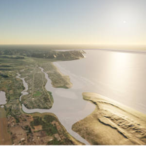
This project simulates a tsunami that might happen in Seaside, Oregon. The tsunami simulation is implemented in Unreal Engine 4 with real geographic data. The simulation features an accurate tsunami simulation from projections of a "500-year tsunami event", referring to the number of years since the last massive earthquake coming from the San Andreas fault. The objective of the simulation is to provide a tactile and visual representation of the possible damage caused by the tsunami, with the addition of simulating evacuation procedures. Some key features of this project are AI Crowd Simulation, Procedural Foliage Generation, Ocean and Tsunami Simulation, and Procedural Building Modeling.
| Attachment | Size |
|---|---|
| 156.59 KB |