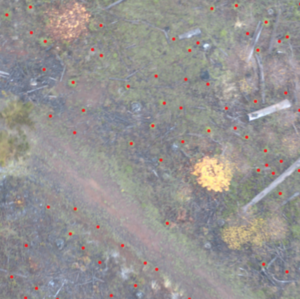
Taking inventory of forests is an expensive and time consuming task that requires a specialist to manually inspect forests to count and identify the trees. The goal of this project is to locate saplings in aerial images of forests in Western Oregon. To address this issue we have implemented a machine learning model to identify saplings using Python and Tensorflow. The model is able to identify saplings in the image based off of how similar a candidate is to the training data of identified saplings. This computer analysis and classification can help minimize the manual identification work needed to be done in the field. This project was done with the supervision of Dr. Bogdan Strimbu in the Department of Forest Engineering, Resources & Management at OSU.
The identification framework consists of two separate approaches. The first process is the segmentation of the image according to spatial and reflectance attributes using a technique called simple linear iterative clustering. This segments the image into classes of similar color. One of these segments of the image is selected as the pool of sapling candidates based on its similarity to images labeled as saplings. This segmentation process helps narrow the search for potential saplings in the image.
Next, a convolutional neural network is trained on images of saplings and instances of other features common to the landscape, such as grass, shrubs, dirt, etc. These classes, as well as what a sapling looks like, will vary between different landscapes. Due to these differences, instances of each class must be identified by hand for each landscape where saplings are to be found. Once we have selected the segment that contains the saplings as well as trained our classifier, we use our classifier to classify each component of the selected segment as a sapling or not a sapling. Based on our confusion matrix of the training and testing data, we believe our model to be at least 95% accurate.
After this classification process, we record the location of every component that was classified as a sapling. Using the geographical coordinate system of the original image, we convert our found sapling locations to geographic coordinates. This format can then be used for analysis in GIS software, a common forestry analysis software tool.
| Attachment | Size |
|---|---|
| 1.95 MB |