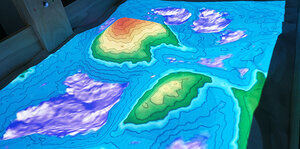
Our project is an augmented reality sandbox with the primary goal of giving civil engineering students a system that will enable them to visualize different terrains and simulate various scenarios. The system works by capturing the terrain of the sand with an Xbox Kinect. This terrain is then sent to a computer which creates a height map of the current terrain. This height map is then overlaid onto the sand via a projector. Various colors representing height data are projected onto the sand, changing color as you move the sand around. This is useful as an educational tool for students and creating different types of scenarios. Aside from playing with the sand and seeing real-time changes, the user has the ability to save terrain that they crafted in the sand. The user then can load that terrain back into the augmentation. The system will change and show the user how to move the sand to imitate the loaded terrain. This way, if there is a specific terrain that the user wants to save, they will always have access to it. The future of this project involves creating a feature that uses game pieces. Game pieces are physical markers that can represent different objects. An example of a use case of this is a disaster relief scenario such as a tsunami. Game pieces could represent different resources. As they are placed in the sandbox, the simulation will show their effect based on the terrain. For instance, if a game piece represents a care package, the range of effect of this care package could be displayed based on the terrain. If it is placed in rough terrain, it will not be reachable from very far away. This sandbox has a plethora of educational purposes, is fun, and allows the users a lot of freedom and creativity.

